![](/images/other/stat-length.png)
![Trail Walking San Sebastián - Pasaïa à San Sebastian par la côte - Photo](https://media.geolcdn.com/t/1900/400/ext.pjpeg?maxdim=2&url=https%3A%2F%2Fstatic1.geolcdn.com%2Fsiteimages%2Fupload%2Ffiles%2F1553511878bg_sport_marche.png)
Pasaïa à San Sebastian par la côte
pacha56
User
![Length](/images/other/stat-length.png)
Length
11.9 km
![Max alt](https://static1.geolcdn.com/siteimages/upload/files/1508320355ic_sort_altitude_max_24dp.png)
Max alt
173 m
![Uphill gradient](https://static1.geolcdn.com/siteimages/upload/files/1508320355ic_sort_den_pos_24dp.png)
Uphill gradient
391 m
![Km-Effort](/images/other/stat-length.png)
Km-Effort
17.1 km
![Min alt](https://static1.geolcdn.com/siteimages/upload/files/1508320355ic_sort_altitude_min_24dp.png)
Min alt
-5 m
![Downhill gradient](https://static1.geolcdn.com/siteimages/upload/files/1508320355ic_sort_den_neg_24dp.png)
Downhill gradient
391 m
![Boucle](https://static1.geolcdn.com/siteimages/upload/files/16400158638029165_repeat_loop_refresh_sync_direction_icon.png)
Boucle
No
Creation date :
2022-06-04 10:18:29.242
Updated on :
2022-06-04 22:40:26.001
![Walking](https://static1.geolcdn.com/sitytour/trail-icons/101.png)
11h21
Difficulty : Easy
![Scan this QR Code to open this trail in the SityTrail application](https://capi.geolives.com/qq0zvz2zws4bq2lad0pu/sitytour/trails/3269978/qr.png?size=200)
FREE GPS app for hiking
About
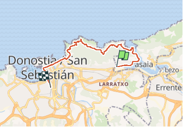
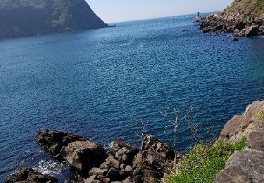
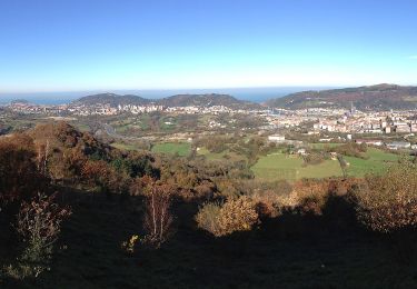
Trail Walking of 11.9 km to be discovered at Autonomous Community of the Basque Country, Gipuzkoa, San Sebastián. This trail is proposed by pacha56.
Description
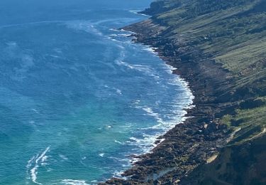
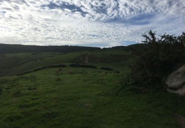
Belle randonnée au départ de Pasaïa en passant par le port, entrée du port ,on monte au dessus et on suit le sentier balisé vers San Sebastian avec de superbes vues sur la côte.. traversée de San Sebastian avec arrêt pâtisserie et gelateria...
Positioning
Country:
Spain
Region :
Autonomous Community of the Basque Country
Department/Province :
Gipuzkoa
Municipality :
San Sebastián
Location:
Unknown
Start:(Dec)
Start:(UTM)
586190 ; 4797177 (30T) N.
Comments
Trails nearby
![Trail On foot San Sebastián - SL-GI 33 Uliari bira - Photo](https://media.geolcdn.com/t/375/260/27a1f47e-d41e-4539-b0a7-2cf8b0f9bdf1.jpeg&format=jpg&maxdim=2)
![On foot On foot](https://static1.geolcdn.com/sitytour/trail-icons/100.png)
SL-GI 33 Uliari bira
On foot
Easy
San Sebastián,
Autonomous Community of the Basque Country,
Gipuzkoa,
Spain
![](/images/other/stat-length.png)
4.9 km | 8.5 km-effort
1h 56min
![](https://static1.geolcdn.com/siteimages/upload/files/16400158638029165_repeat_loop_refresh_sync_direction_icon.png)
Yes
![Trail Walking Pasaia - Pasaia Donibane - Photo](https://media.geolcdn.com/t/375/260/0553a38d-8a0d-4fa0-800e-ecb893adf7b5.jpg&format=jpg&maxdim=2)
![Walking Walking](https://static1.geolcdn.com/sitytour/trail-icons/101.png)
Pasaia Donibane
Walking
Medium
Pasaia,
Autonomous Community of the Basque Country,
Gipuzkoa,
Spain
![](/images/other/stat-length.png)
7.4 km | 11.2 km-effort
2h 20min
![](https://static1.geolcdn.com/siteimages/upload/files/16400158638029165_repeat_loop_refresh_sync_direction_icon.png)
Yes
![Trail Walking Pasaia - Littoral du Jaizkibel I - Photo](https://media.geolcdn.com/t/375/260/c0b73d7c-a983-4f61-bb9e-e7eb6af85a90.jpeg&format=jpg&maxdim=2)
![Walking Walking](https://static1.geolcdn.com/sitytour/trail-icons/101.png)
Littoral du Jaizkibel I
Walking
Very difficult
Pasaia,
Autonomous Community of the Basque Country,
Gipuzkoa,
Spain
![](/images/other/stat-length.png)
10.3 km | 18.6 km-effort
3h 42min
![](https://static1.geolcdn.com/siteimages/upload/files/16400158638029165_repeat_loop_refresh_sync_direction_icon.png)
Yes
![Trail Walking Pasaia - Piemont du Jaizkibel Pays Basque Espagne - Photo](https://media.geolcdn.com/t/375/260/fd334848-f3d2-471b-86a8-42eac21c68f8.jpg&format=jpg&maxdim=2)
![Walking Walking](https://static1.geolcdn.com/sitytour/trail-icons/101.png)
Piemont du Jaizkibel Pays Basque Espagne
Walking
Very easy
Pasaia,
Autonomous Community of the Basque Country,
Gipuzkoa,
Spain
![](/images/other/stat-length.png)
9.8 km | 15.2 km-effort
7h 21min
![](https://static1.geolcdn.com/siteimages/upload/files/16400158638029165_repeat_loop_refresh_sync_direction_icon.png)
Yes
![Trail Walking Pasaia - le batier à la sauce Basque du phiphidechagny - Photo](https://media.geolcdn.com/t/375/260/ext.jpg?maxdim=2&url=https%3A%2F%2Fservices.sitytrail.com%2FGeolivesWS%2FDownloadMedia.ashx%3FTrailID%3D1134598%26Media%3Dfix__20190413165921.jpg)
![Walking Walking](https://static1.geolcdn.com/sitytour/trail-icons/101.png)
le batier à la sauce Basque du phiphidechagny
Walking
Difficult
Pasaia,
Autonomous Community of the Basque Country,
Gipuzkoa,
Spain
![](/images/other/stat-length.png)
25 km | 41 km-effort
7h 35min
![](https://static1.geolcdn.com/siteimages/upload/files/16400158638029165_repeat_loop_refresh_sync_direction_icon.png)
Yes
![Trail Walking Pasaia - le batier à la sauce Basque du phiphidechagny - Photo](https://media.geolcdn.com/t/375/260/ext.jpg?maxdim=2&url=https%3A%2F%2Fservices.sitytrail.com%2FGeolivesWS%2FDownloadMedia.ashx%3FTrailID%3D1134504%26Media%3Dfix__20190413165921.jpg)
![Walking Walking](https://static1.geolcdn.com/sitytour/trail-icons/101.png)
le batier à la sauce Basque du phiphidechagny
Walking
Difficult
Pasaia,
Autonomous Community of the Basque Country,
Gipuzkoa,
Spain
![](/images/other/stat-length.png)
25 km | 41 km-effort
7h 35min
![](https://static1.geolcdn.com/siteimages/upload/files/16400158638029165_repeat_loop_refresh_sync_direction_icon.png)
Yes
![Trail On foot San Sebastián - SL-GI 3 San Markos - Photo](https://media.geolcdn.com/t/375/260/2fe8878e-9c02-4dc2-97ba-4e40ea438d03.jpeg&format=jpg&maxdim=2)
![On foot On foot](https://static1.geolcdn.com/sitytour/trail-icons/100.png)
SL-GI 3 San Markos
On foot
Easy
San Sebastián,
Autonomous Community of the Basque Country,
Gipuzkoa,
Spain
![](/images/other/stat-length.png)
6.6 km | 10 km-effort
2h 16min
![](https://static1.geolcdn.com/siteimages/upload/files/16400158638029165_repeat_loop_refresh_sync_direction_icon.png)
Yes
![Trail On foot Errenteria - SL-GI 4 Txoritokieta - Photo](https://media.geolcdn.com/t/375/260/b48432f2-566c-4bd7-bcf2-41464a792f25.jpeg&format=jpg&maxdim=2)
![On foot On foot](https://static1.geolcdn.com/sitytour/trail-icons/100.png)
SL-GI 4 Txoritokieta
On foot
Easy
Errenteria,
Autonomous Community of the Basque Country,
Gipuzkoa,
Spain
![](/images/other/stat-length.png)
3.4 km | 5.1 km-effort
1h 9min
![](https://static1.geolcdn.com/siteimages/upload/files/16400158638029165_repeat_loop_refresh_sync_direction_icon.png)
Yes